
Since its public introduction in 2022, the National Broadband Serviceable Location Fabric (Fabric) dataset is now in use by United States policymakers and the industry for a variety of initiatives. CostQuest is the official location data vendor to the FCC, NTIA, 12 other Federal Broadband Granting Agencies, 56 State/Territory entities, and over 3000 ISPs for the National Location Fabric dataset, as well as cost modeling for the cost of delivering broadband service to every location in the country.
First with the FCC’s Broadband Data Collection, the Location Fabric was enacted through the Broadband DATA Act signed into law by President Trump, and later evolved for use in the Broadband, Equity, Access, and Deployment (BEAD) program through the Bipartisan Infrastructure Law, and beyond.
In this article we’ll first briefly review how the Fabric came to be, what the Fabric is, and how it’s created. Then, discuss the program needs for this national location database, and what government programs use the Fabric to date.
Introduction of the Fabric – The new location dataset on the block
The creation of the Location Fabric database was triggered by law through the Broadband DATA Act, to support the FCC’s creation of a more accurate location-level broadband data collection system, the Broadband Data Collection, to replace the previous reporting mechanism, Form 477.
CostQuest was contracted by the Federal Communications Commission (FCC) in late 2021, to be the official contractor and provider of the National Broadband Serviceable Location Fabric database to support the FCC’s Broadband Data Collection Program, which launched in 2022.
The FCC uses the Location Fabric combined with providers service availability data to create its National Broadband Maps. The first-ever maps that showcase the state of broadband availability across the US at the location-level. Compared to the previous Form 477 data that contained reported broadband service coverage at the census-block data level, and inadvertently misrepresented service availability due to its lack of geographic granularity.
The introduction of the Location Fabric enabled users to report and analyze broadband service availability across over 116 million location records, compared to ~8 million census-block records in the Form 477 process.
This new data collection process using the Fabric, was a catalyst for a more granular mechanism of mapping and analyzing broadband availability across the US. Now, through the use of the Fabric, policymakers are able to accurately identify funding locations and efficiently deploy taxpayer dollars to areas of need.
What is the Location Fabric?
The Location Fabric is a geospatial location database of Broadband Serviceable Locations (BSL). The definition of a BSL is defined by the FCC as “a business or residential location in the United States at which fixed broadband Internet access service is, or can be, installed.”
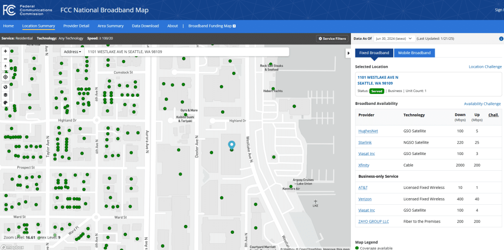
When you look at the FCC’s National Broadband Map, the Location Fabric is the green points you see on location structures when you zoom in on the map.
How is the Fabric Constructed?
To identify the locations in the Fabric, CostQuest uses multiple data sources to develop the Fabric database including satellite imagery, parcels, building footprints, tax assessor records, road segments data, census information, various address databases, and much more.
These datasets are then used to train an artificial intelligence engine using machine learning models to identify all BSLs in the United States and U.S. Territories, combined with visual verification for further review.
Developing the Fabric to identify all BSLs is not a one size fits all process and involves multiple models to best attribute a structure as a BSL. Utilizing these advanced technologies, coupled with our in-house experts, the Fabric is an industry leading dataset with the most accurate information available today.
The Role of the Fabric in Government Policymaking and Funding
A variety of government agencies use the Location Fabric to help them understand broadband deployment and implement broadband programs. The Fabric offers an unmatched insight into the state of broadband across the United States and territories.
First, it offers precise and accurate information on where broadband is available and where it is not at the location-level, enabling policymakers and industry entities to efficiently target funding to expand broadband service to where it’s needed most.
Second, when the Fabric is coupled with CostQuest’s cost estimates, as is used in the BEAD, it serves as a benchmark for governments to base their grant programs with the necessary information required to run an efficient program. The Fabric and cost estimates together are an insightful tool to minimize waste, fraud, and abuse of funding dollars.
All Federal agencies that manage broadband funding programs have access to the Fabric data. The current federal users of the Location Fabric Data are:
- The Federal Communications Commission
- Broadband Data Collection
- National Broadband Map & National Broadband Funding Map
- Affordable Connectivity Program Obligations
- Universal Service Fund
- Rural Digital Opportunity Fund (RDOF)
- Enhanced Alternative Connect America Cost Model (Enhanced ACAM)
- National Telecommunications and Information Administration
- Broadband Equity, Access, and Deployment (BEAD) Fund
- United States Department of Agriculture programs
- United States Department of the Treasury programs
How and Why Does the Location Fabric Change?
There is a challenge process managed by the FCC that enables interested parties to report suspected issues and problems with the Fabric, which is updated on a bi-annual basis. Other changes to the Fabric come about due to CostQuest’s continuous internal improvement efforts such as updates and modification to data models, data sources, and identification of new data, such as new construction data, and models.
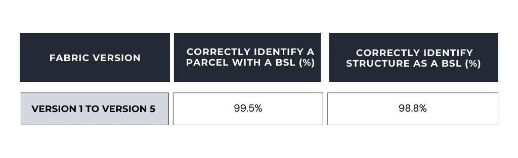
With over 116 million total locations, the precision of the Location Fabric database continuously improves. CostQuest’s Fabric models correctly identify a parcel with a Broadband Serviceable Location 99.5% of the time, and identifies the correct structure on that parcel as the BSL 98.8% of the time.
Types of Fabric Licensing
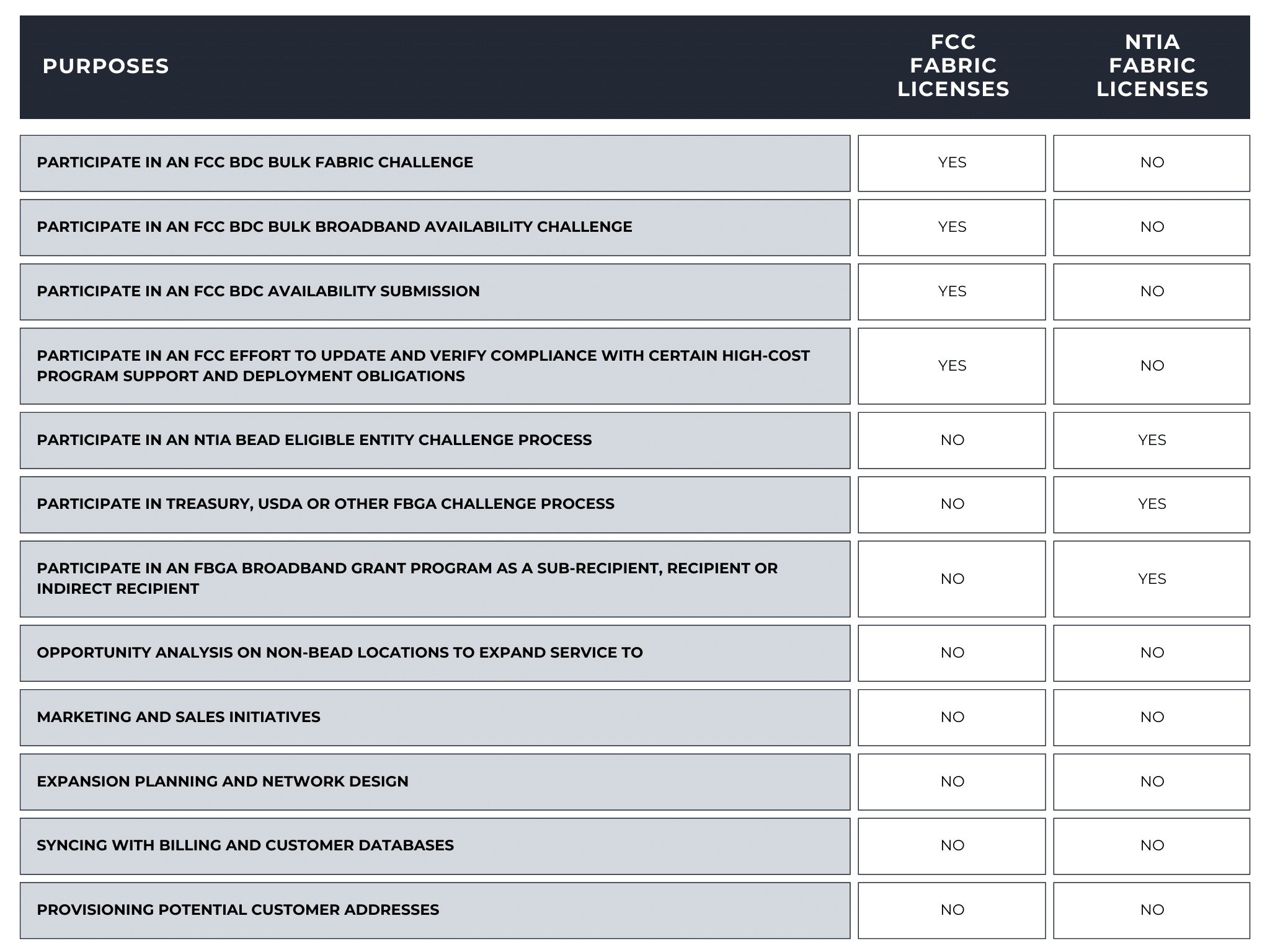
Federal Program Licensing – Restricted Uses
CostQuest provides a no-cost Fabric license through two distinct paths. Each path supports a distinct set of purposes within Federal programs. To decide on the appropriate license, you need to first understand what you are trying to accomplish with the Fabric Data.
If you need the Fabric to file challenges to the data shown on the National Broadband Map or to participate in the FCC Broadband Data Collection, you will need to obtain an FCC Fabric license. The FCC has posted several articles describing the process. See: https://help.bdc.fcc.gov/hc/en-us/articles/10419121200923-How-Entities-Can-Access-the-Location-Fabric.
If you need the Fabric to participate in a Federal Broadband Granting Agency (FBGA) program, you will need an NTIA Fabric license. NTIA licenses are available for recipients, sub-recipients, and challengers.
The table below provides a quick summary of purposes that qualify an entity for a Fabric Data license.
Commercial Licensing – Use for Internal Business Operations
To use the Fabric data for business functions outside the permitted uses under the FCC and NTIA Fabric License Groups, commercial licenses are available for entities to purchase the data to use the Fabric data for:
- Broadband planning
- Opportunity analysis
- Broadband expansion mapping
- Network design
- Sales and marketing
- Syncing billing and customer databases
- Provisioning customer addresses
Contact [email protected] for questions about commercial licensing.
The Fabric Data is a Powerful Tool for the Broadband World
The Fabric is a very powerful database that has enormous importance in setting broadband policy for the United States and informing the efficient distribution of funding to unserved and underserved areas. The introduction of the Fabric first started with the FCC’s Broadband Data Collection and evolved to support NTIA’s BEAD and other Federal Broadband Granting Authority Programs.
The Fabric is now used by all internet providers and carriers to fulfill federal reporting requirements or participate in federal broadband funding programs. And in use commercially by a multitude of internet service providers and other private entities to support a range of internal business operations. The Fabrics wide use across government and commercial entities has created standardization and continuity across the various programs and entities.
The concept of the Location Fabric, identifying every residential and business structure that is or can be connected to broadband, also has potential to help rationalize and inform broadband availability and investment decisions, if applied and built in other nations.
Disclaimer
This communication does not reflect the opinion of the National Telecommunications and Information Administration (NTIA) and Federal Communications Commission (FCC). The NTIA and FCC are not responsible for the information or views in this communication and is not responsible for the accuracy, completeness, timeliness of such information or views.