
Montgomery County, VA GIS Data
Virginia
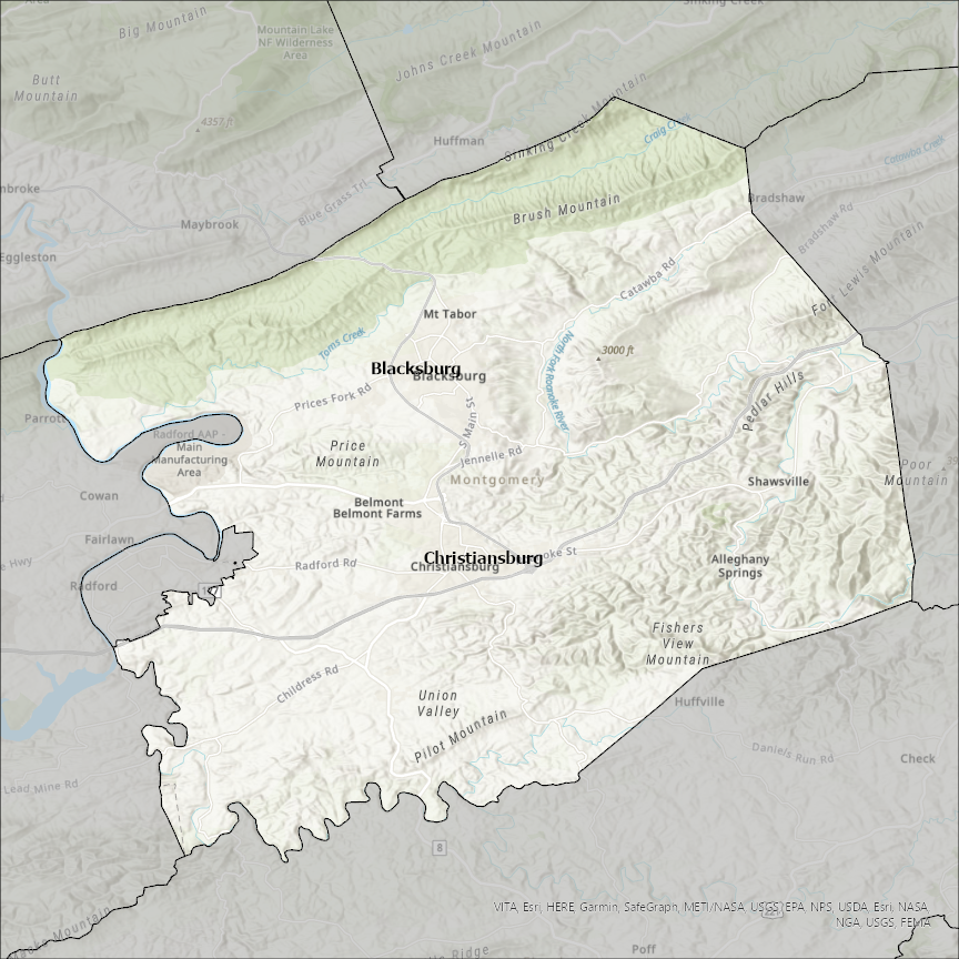
Montgomery county
CostQuest’s BroadbandFabric data developed by broadband experts and blended with machine learning, is the perfect solution for the challenges broadband decision-makers face. CostQuest provides an accurate view of Broadband Serviceable locations (coordinates of structures eligible to receive service) that can universally tie to other key data attributes such as Service Availability, Engineering and Construction, Costs and Economics, and Demand and Demographics. Let CostQuest power your data-driven decision making with one-of-a-kind data built for the Broadband evolution.
Contact UsCities included
- Irving
- Hillsboro
- Fillmore
- Coosada
- Pike Road
- Montgomery
- Donnellson
- Schram City
- Glenwood
- New Market
- Alamo
- Oden
- Norman
- Mount Ida
- Black Springs
- Raymond
- Ohlman
- Washington
- Vidalia
- Tarrytown
- Mount Vernon
- Uvalda
- Higgston
- Alston
- Ailey
- Witt
- Wenonah
- Nokomis
- Litchfield
- Walshville
- Waggoner
- Taylor Springs
- Farmersville
- Coffeen
- Coalton
- Butler
- Harvel
- Panama
- Wingate
- Waynetown
- Waveland
- New Ross
- New Richmond
- Linden
- Ladoga
- Darlington
- Crawfordsville
- Barnesville
- Villisca
- Stanton
- Red Oak
- Grant
- Elliott
- Coburg
- Elk City
- Tyro
- Liberty
- Independence
- Havana
- Dearing
- Cherryvale
- Coffeyville
- Caney
- Parsons
- Guthrie
- Camargo
- Mount Sterling
- Jeffersonville
- Oak Grove
- Washington Grove
- Glen Echo
- Garrett Park
- Gaithersburg
- Chevy Chase Village
- Chevy Chase View
- Chevy Chase Section Three
- Chevy Chase Section Five
- Chevy Chase
- Brookeville
- Takoma Park
- Somerset
- Rockville
- Poolesville
- North Chevy Chase
- Martin's Additions
- Laytonsville
- Kensington
- Kilmichael
- Winona
- Duck Hill
- Hermann
- Wellsville
- Rhineland
- New Florence
- Montgomery City
- Middletown
- McKittrick
- Jonesburg
- High Hill
- Bellflower
- Palatine Bridge
- Nelliston
- Hagaman
- Fultonville
- Johnstown
- St. Johnsville
- Fort Plain
- Fort Johnson
- Fonda
- Canajoharie
- Amsterdam
- Ames
- Norman
- Troy
- Star
- Mount Gilead
- Candor
- Biscoe
- Foxfire
- West Carrollton
- Phillipsburg
- Vandalia
- Trotwood
- Riverside
- Miamisburg
- Kettering
- Oakwood
- New Lebanon
- Moraine
- Germantown
- Farmersville
- Brookville
- Englewood
- Dayton
- Clayton
- Centerville
- Union
- Huber Heights
- Springboro
- Carlisle
- Verona
- Bellbrook
- Beavercreek
- Franklin
- South Coffeyville
- Telford
- Boyertown
- Spring City
- Phoenixville
- Rockledge
- Red Hill
- Pennsburg
- North Wales
- Pottstown
- Norristown
- Narberth
- Philadelphia
- Bridgeport
- Lansdale
- Jenkintown
- Hatfield
- Hatboro
- Green Lane
- East Greenville
- Conshohocken
- Collegeville
- Bryn Athyn
- Ambler
- West Conshohocken
- Trappe
- Souderton
- Schwenksville
- Royersford
- Clarksville
- Humble
- Cleveland
- Woodloch
- Woodbranch
- Shenandoah
- Willis
- Stagecoach
- Oak Ridge North
- Splendora
- Roman Forest
- Patton Village
- Panorama Village
- Montgomery
- Magnolia
- Cut and Shoot
- Conroe
- Tomball
- Houston
- Plum Grove
- Radford
- Christiansburg
- Leesburg
- Blacksburg